


Calanque de L’Erevine (Côte Bleue)

GOHIER
User
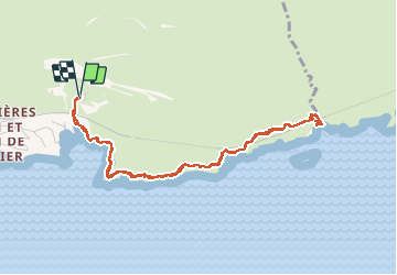

Length
5.5 km

Max alt
66 m

Uphill gradient
150 m
Km-Effort
7.5 km

Min alt
6 m

Downhill gradient
151 m
Boucle
Yes
Creation date :
2020-10-07 11:37:36.0
Updated on :
2020-10-07 15:40:31.358
3h54
Difficulty : Unknown

FREE GPS app for hiking
 SityTrail
IGN / Geographical institutes
SityTrail Plus
The world is yours!
About
Trail Walking of 5.5 km to be discovered at Provence-Alpes-Côte d'Azur, Bouches-du-Rhône, Ensuès-la-Redonne. This trail is proposed by GOHIER.
Description
Tres bonne baignade un 7 octobre
Positioning
Country:
France
Region :
Provence-Alpes-Côte d'Azur
Department/Province :
Bouches-du-Rhône
Municipality :
Ensuès-la-Redonne
Location:
Unknown
Start:(Dec)
Start:(UTM)
679840 ; 4800219 (31T) N.
Comments