Mazenay les deux monts page 17

grasgilbert
User


Length
13.5 km

Max alt
542 m

Uphill gradient
442 m
Km-Effort
19.4 km

Min alt
276 m

Downhill gradient
440 m
Boucle
Yes
Creation date :
2020-10-08 11:46:35.857
Updated on :
2023-10-12 18:15:44.572
4h24
Difficulty : Very difficult

FREE GPS app for hiking
 SityTrail
IGN / Geographical institutes
SityTrail Plus
The world is yours!
About
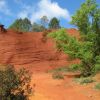
Trail Walking of 13.5 km to be discovered at Bourgogne-Franche-Comté, Saône-et-Loire, Saint-Sernin-du-Plain. This trail is proposed by grasgilbert.
Description
superbe randonnée pour randonneurs averti
Positioning
Country:
France
Region :
Bourgogne-Franche-Comté
Department/Province :
Saône-et-Loire
Municipality :
Saint-Sernin-du-Plain
Location:
Unknown
Start:(Dec)
Start:(UTM)
621524 ; 5196176 (31T) N.
Comments