


Bramousse

Sorriaux
User

Length
15.9 km

Max alt
2305 m

Uphill gradient
926 m
Km-Effort
28 km

Min alt
1410 m

Downhill gradient
950 m
Boucle
Yes
Creation date :
2020-10-10 07:50:32.082
Updated on :
2020-10-10 15:45:48.775
5h12
Difficulty : Very easy

FREE GPS app for hiking
 SityTrail
IGN / Geographical institutes
SityTrail Plus
The world is yours!
About
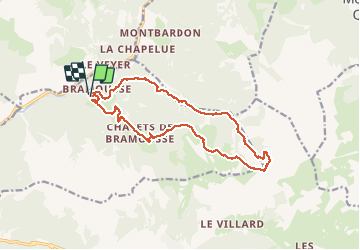
Trail Walking of 15.9 km to be discovered at Provence-Alpes-Côte d'Azur, Hautes-Alpes, Guillestre. This trail is proposed by Sorriaux.
Positioning
Country:
France
Region :
Provence-Alpes-Côte d'Azur
Department/Province :
Hautes-Alpes
Municipality :
Guillestre
Location:
Unknown
Start:(Dec)
Start:(UTM)
321450 ; 4952971 (32T) N.
Comments