


09 Velo um den Aegerisee

kurt
User
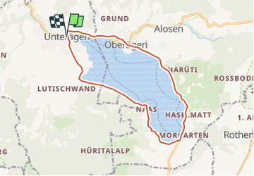

Length
14.2 km

Max alt
774 m

Uphill gradient
140 m
Km-Effort
16.1 km

Min alt
722 m

Downhill gradient
142 m
Boucle
Yes
Creation date :
2014-12-11 00:00:00.0
Updated on :
2014-12-11 00:00:00.0
--
Difficulty : Unknown

FREE GPS app for hiking
 SityTrail
IGN / Geographical institutes
SityTrail Plus
The world is yours!
About
Trail Via ferrata of 14.2 km to be discovered at Zug, Unknown, Unterägeri. This trail is proposed by kurt.
Positioning
Country:
Switzerland
Region :
Zug
Department/Province :
Unknown
Municipality :
Unterägeri
Location:
Unknown
Start:(Dec)
Start:(UTM)
468496 ; 5220510 (32T) N.
Comments