


2020-10-11_19h23m18_MAULEON-ESBAREICH-MAULEON G4 en boucle

mitch1952
User
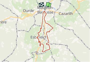

Length
7.5 km

Max alt
793 m

Uphill gradient
277 m
Km-Effort
11.2 km

Min alt
575 m

Downhill gradient
275 m
Boucle
Yes
Creation date :
2020-10-11 17:23:19.669
Updated on :
2022-06-07 11:17:58.166
2h33
Difficulty : Medium

FREE GPS app for hiking
 SityTrail
IGN / Geographical institutes
SityTrail Plus
The world is yours!
About
Trail Walking of 7.5 km to be discovered at Occitania, Hautespyrenees, Mauléon-Barousse. This trail is proposed by mitch1952.
Description
départ Ger 8h
départ rando parking hôtel restaurant des Pyrénées 9h30
retrouvailles avec le G3 a l'aire de PN pour partager ensemble un moment de convivialité aux environs de 12h30
Positioning
Country:
France
Region :
Occitania
Department/Province :
Hautespyrenees
Municipality :
Mauléon-Barousse
Location:
Unknown
Start:(Dec)
Start:(UTM)
301585 ; 4759170 (31T) N.
Comments