Trail Horseback riding Naussac-Fontanes - Boucle Totale Nouveau chaos granitique avec points hebergeurs  - Photo

Boucle Totale Nouveau chaos granitique avec points hebergeurs

© OpenStreetMap contributors
Length
Length
221 km
Max alt
Max alt
1699 m
Uphill gradient
Uphill gradient
5899 m
Km-Effort
Km-Effort  
300 km
Min alt
Min alt
617 m
Downhill gradient
Downhill gradient
5897 m
Boucle
Boucle
No
Creation date :
2020-10-12 12:16:50.249
Updated on :
2021-12-09 17:02:28.057

(0 Reviews)

Horseback riding
Horseback riding
18m
Difficulty : Easy

Scan this QR Code to open this trail in the SityTrail application

FREE GPS app for hiking

Logo SityTrail SityTrail

IGN / Geographical institutes

Download SityTrail from the App Store Download SityTrail from Google Play

Logo SityTrail SityTrail World

The world is yours!

Download SityTrail from the App Store Download SityTrail from Google Play Download SityTrail on Huawei AppGallery

About

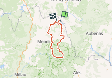
Trail Horseback riding of 221 km to be discovered at Occitania, Lozère, Naussac-Fontanes. This trail is proposed by Lozère Cheval.

Description

Sans camping Val Cévennes ni Mas Barque à rajouter

Elevation profile

Points of interest

Point of interest Rocles - Passage tunnel sous RN 88 attention. Si eau , passer sur route Danger - Photo
Lozère Cheval
Point of interest Mont Lozère et Goulet - Hôtel les Sources Chasserades - Photo
Lozère Cheval
MONT LOZÈRE ET GOULET 
Point of interest Mont Lozère et Goulet - Hôtel le Refuge - Photo
Lozère Cheval
MONT LOZÈRE ET GOULET 
Point of interest Pont de Montvert - Sud Mont Lozère - Cavale du Ventalon - Photo
Lozère Cheval
PONT DE MONTVERT - SUD MONT LOZÈRE 
Point of interest Laubert - La Pontière - Photo
Lozère Cheval
LAUBERT 
Point of interest Arzenc-de-Randon - Le Giraldès  chez Valy - Photo
Lozère Cheval
ARZENC-DE-RANDON 
Point of interest Naussac-Fontanes - Grange de Pradelou - Photo
Lozère Cheval
NAUSSAC-FONTANES 
Point of interest Florac Trois Rivières - Camping Val Cévennes - Photo
Lozère Cheval
FLORAC TROIS RIVIÈRES 
Point of interest Vialas - Mas de la Barque - Photo
Lozère Cheval
Point of interest Saint-André-de-Lancize - Gîte Equestre les Mourènes - Photo
Lozère Cheval
SAINT-ANDRÉ-DE-LANCIZE 
Point of interest Mont Lozère et Goulet - Gite de l'Escoutal - Photo
Lozère Cheval
MONT LOZÈRE ET GOULET 
Point of interest Rocles - Palhères - Photo
Lozère Cheval
ROCLES 
Point of interest Cheylard-l'Évêque - Le refuge du Moure - Photo
Lozère Cheval
CHEYLARD-L'ÉVÊQUE 

Positioning

Country:
France
Region :
Occitania
Department/Province :
Lozère
Municipality :
Naussac-Fontanes
Location:
Unknown
Start:(UTM)
562256 ; 4957723 (31T) N.

Trails nearby

Trail Walking Naussac-Fontanes - naussac - Photo
Walking
olivier78000

Walking

Easy
(1)
Naussac-Fontanes, Occitania, Lozère, France
7.9 km | 10.2 km-effort
2h 6min
Yes
Trail Mountain bike Langogne - Espace VTT FFC du Gévaudan - n°08 - Circuit  du Ras Chambon - Photo
Mountain bike
tracegps

Mountain bike

Difficult
(2)
Langogne, Occitania, Lozère, France
17.2 km | 22 km-effort
2h 15min
Yes
Trail Horseback riding Rocles - Jojo2  - Photo
Horseback riding
ophness

Horseback riding

Medium
(1)
Rocles, Occitania, Lozère, France
17.3 km | 22 km-effort
2h 55min
No
Trail Road bike Langogne - Langogne, le nouveau monde - Photo
Road bike
nadd73

Road bike

Medium
Langogne, Occitania, Lozère, France
68 km | 85 km-effort
4h 31min
Yes
Trail Road bike Langogne - NAUSSAC - COL DE LA PIERRE PLANTEE - Photo
Road bike
jean-marie.parachini

Road bike

Easy
Langogne, Occitania, Lozère, France
76 km | 91 km-effort
6h 20min
Yes
Trail Road bike Langogne - NAUSSAC - FORÊT DE MERCOIRE - Photo
Road bike
jean-marie.parachini

Road bike

Medium
Langogne, Occitania, Lozère, France
68 km | 81 km-effort
5h 40min
Yes
Trail Road bike Langogne - NAUSSAC - CHAPEAUROUX - Photo
Road bike
jean-marie.parachini

Road bike

Medium
Langogne, Occitania, Lozère, France
74 km | 94 km-effort
6h 29min
No
Trail Road bike Langogne - NAUSSAC - COL CROIX DE BOR ET COL DES 3 SOEURS - Photo
Road bike
jean-marie.parachini

Road bike

Medium
Langogne, Occitania, Lozère, France
67 km | 83 km-effort
5h 19min
Yes
Trail Walking Auroux - Auroux en passant par Soulage et la croix de Parpaillon  - Photo
Walking
alainjoseph6

Walking

Medium
Auroux, Occitania, Lozère, France
9.6 km | 13.3 km-effort
3h 17min
Yes


Close
My subscriptions