
LP80_Noyelles Nord_3.8km (RS)

BAIE de SOMME & alentours
Autour de la Baie à pieds
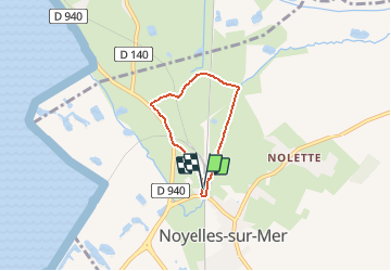

Length
3.8 km

Max alt
8 m

Uphill gradient
11 m
Km-Effort
3.9 km

Min alt
1 m

Downhill gradient
12 m
Boucle
Yes
Creation date :
2020-10-12 15:50:07.924
Updated on :
2020-10-12 15:54:00.25
53m
Difficulty : Easy

FREE GPS app for hiking
 SityTrail
IGN / Geographical institutes
SityTrail Plus
The world is yours!
About
Trail Walking of 3.8 km to be discovered at Hauts-de-France, Somme, Noyelles-sur-Mer. This trail is proposed by BAIE de SOMME & alentours.
Description
Rando Santé _Pkg de la gare
Photos
 - Photo 1")
Positioning
Country:
France
Region :
Hauts-de-France
Department/Province :
Somme
Municipality :
Noyelles-sur-Mer
Location:
Unknown
Start:(Dec)
Start:(UTM)
407506 ; 5560281 (31U) N.
Comments