


Refuge drEspingo - Bagnères de Luchon

ARVIEU
User
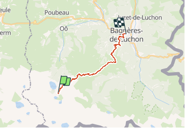

Length
16.7 km

Max alt
2272 m

Uphill gradient
722 m
Km-Effort
30 km

Min alt
635 m

Downhill gradient
1976 m
Boucle
No
Creation date :
2020-10-12 19:20:06.989
Updated on :
2020-10-12 19:23:19.164
5h25
Difficulty : Very difficult

FREE GPS app for hiking
 SityTrail
IGN / Geographical institutes
SityTrail Plus
The world is yours!
About
Trail Walking of 16.7 km to be discovered at Occitania, Haute-Garonne, Oô. This trail is proposed by ARVIEU.
Positioning
Country:
France
Region :
Occitania
Department/Province :
Haute-Garonne
Municipality :
Oô
Location:
Unknown
Start:(Dec)
Start:(UTM)
295357 ; 4734282 (31T) N.
Comments