


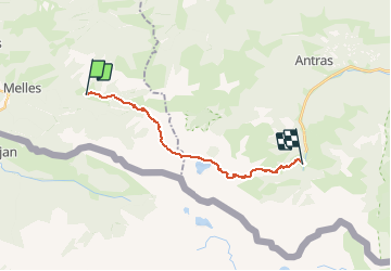
Labach - Eylie d'en haut

ARVIEU
User

Length
17.2 km

Max alt
2228 m

Uphill gradient
1593 m
Km-Effort
39 km

Min alt
947 m

Downhill gradient
1634 m
Boucle
No
Creation date :
2020-10-12 20:14:52.291
Updated on :
2020-10-12 20:16:55.027
7h31
Difficulty : Very difficult

FREE GPS app for hiking
 SityTrail
IGN / Geographical institutes
SityTrail Plus
The world is yours!
About
Trail Walking of 17.2 km to be discovered at Occitania, Haute-Garonne, Melles. This trail is proposed by ARVIEU.
Positioning
Country:
France
Region :
Occitania
Department/Province :
Haute-Garonne
Municipality :
Melles
Location:
Unknown
Start:(Dec)
Start:(UTM)
320267 ; 4748149 (31T) N.
Comments