


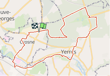
Parcs et jardins de l'Yerres

dmatignon
User

Length
12.1 km

Max alt
122 m

Uphill gradient
154 m
Km-Effort
14.1 km

Min alt
31 m

Downhill gradient
154 m
Boucle
Yes
Creation date :
2020-10-13 11:47:40.602
Updated on :
2020-10-17 14:53:29.779
2h55
Difficulty : Easy

FREE GPS app for hiking
 SityTrail
IGN / Geographical institutes
SityTrail Plus
The world is yours!
About
Trail Walking of 12.1 km to be discovered at Ile-de-France, Essonne, Crosne. This trail is proposed by dmatignon.
Description
Boucle permettant de découvrir plusieurs parcs et jardins le long de l'Yerres.
Positioning
Country:
France
Region :
Ile-de-France
Department/Province :
Essonne
Municipality :
Crosne
Location:
Unknown
Start:(Dec)
Start:(UTM)
461116 ; 5396908 (31U) N.
Comments