


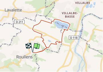
roullens-lac de taure 01 VM

dufland
User

Length
7.5 km

Max alt
219 m

Uphill gradient
138 m
Km-Effort
9.4 km

Min alt
133 m

Downhill gradient
138 m
Boucle
Yes
Creation date :
2020-10-13 12:14:37.416
Updated on :
2024-02-24 15:05:51.152
2h07
Difficulty : Medium

FREE GPS app for hiking
 SityTrail
IGN / Geographical institutes
SityTrail Plus
The world is yours!
About
Trail Walking of 7.5 km to be discovered at Occitania, Aude, Roullens. This trail is proposed by dufland.
Positioning
Country:
France
Region :
Occitania
Department/Province :
Aude
Municipality :
Roullens
Location:
Unknown
Start:(Dec)
Start:(UTM)
441279 ; 4779565 (31T) N.
Comments