


chef du pont

AMOURETTE
User
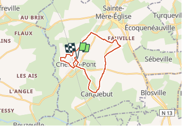

Length
11.4 km

Max alt
31 m

Uphill gradient
89 m
Km-Effort
12.6 km

Min alt
1 m

Downhill gradient
88 m
Boucle
Yes
Creation date :
2020-10-13 12:28:06.558
Updated on :
2020-10-13 15:21:58.643
2h23
Difficulty : Very easy

FREE GPS app for hiking
 SityTrail
IGN / Geographical institutes
SityTrail Plus
The world is yours!
About
Trail Walking of 11.4 km to be discovered at Normandy, Manche, Sainte-Mère-Église. This trail is proposed by AMOURETTE.
Positioning
Country:
France
Region :
Normandy
Department/Province :
Manche
Municipality :
Sainte-Mère-Église
Location:
Chef-du-Pont
Start:(Dec)
Start:(UTM)
620352 ; 5471867 (30U) N.
Comments