


2020-10-13_16h26m36_yt7jslelldY

Maca8284
User
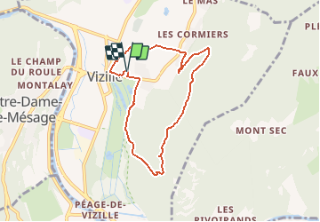

Length
7.1 km

Max alt
575 m

Uphill gradient
320 m
Km-Effort
11.4 km

Min alt
277 m

Downhill gradient
320 m
Boucle
Yes
Creation date :
2020-10-13 14:26:37.147
Updated on :
2020-10-13 16:23:56.969

FREE GPS app for hiking
 SityTrail
IGN / Geographical institutes
SityTrail Plus
The world is yours!
About
Trail of 7.1 km to be discovered at Auvergne-Rhône-Alpes, Isère, Vizille. This trail is proposed by Maca8284.
Positioning
Country:
France
Region :
Auvergne-Rhône-Alpes
Department/Province :
Isère
Municipality :
Vizille
Location:
Unknown
Start:(Dec)
Start:(UTM)
718508 ; 4995201 (31T) N.
Comments