


balade avec marc

gillou1947
User
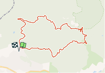

Length
12.8 km

Max alt
150 m

Uphill gradient
277 m
Km-Effort
16.5 km

Min alt
15 m

Downhill gradient
275 m
Boucle
Yes
Creation date :
2020-10-14 11:41:28.787
Updated on :
2020-10-14 15:18:21.37
3h35
Difficulty : Very easy

FREE GPS app for hiking
 SityTrail
IGN / Geographical institutes
SityTrail Plus
The world is yours!
About
Trail Walking of 12.8 km to be discovered at Provence-Alpes-Côte d'Azur, Var, Saint-Raphaël. This trail is proposed by gillou1947.
Positioning
Country:
France
Region :
Provence-Alpes-Côte d'Azur
Department/Province :
Var
Municipality :
Saint-Raphaël
Location:
Unknown
Start:(Dec)
Start:(UTM)
323561 ; 4814203 (32T) N.
Comments