


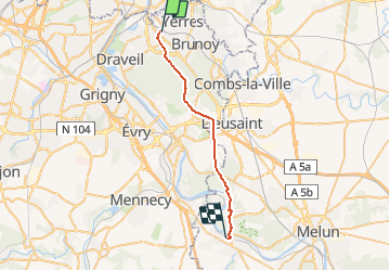
Montgeron - Saint Fargeau Ponthierry

JackyCouturier
User

Length
24 km

Max alt
99 m

Uphill gradient
203 m
Km-Effort
27 km

Min alt
38 m

Downhill gradient
208 m
Boucle
No
Creation date :
2020-10-15 13:07:27.697
Updated on :
2020-11-19 17:18:30.983
8m
Difficulty : Easy

FREE GPS app for hiking
 SityTrail
IGN / Geographical institutes
SityTrail Plus
The world is yours!
About
Trail Walking of 24 km to be discovered at Ile-de-France, Essonne, Montgeron. This trail is proposed by JackyCouturier.
Description
Chemin de Compostelle
Voie de Paris à Vézelay
Positioning
Country:
France
Region :
Ile-de-France
Department/Province :
Essonne
Municipality :
Montgeron
Location:
Unknown
Start:(Dec)
Start:(UTM)
460410 ; 5395131 (31U) N.
Comments