


Commenaille 18.7km 20201015

cmike39
User
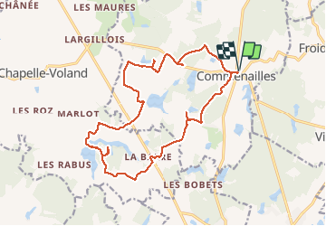

Length
18.9 km

Max alt
228 m

Uphill gradient
219 m
Km-Effort
22 km

Min alt
196 m

Downhill gradient
219 m
Boucle
Yes
Creation date :
2020-10-15 07:05:27.716
Updated on :
2020-10-15 15:36:58.557
4h20
Difficulty : Very easy

FREE GPS app for hiking
 SityTrail
IGN / Geographical institutes
SityTrail Plus
The world is yours!
About
Trail Walking of 18.9 km to be discovered at Bourgogne-Franche-Comté, Jura, Commenailles. This trail is proposed by cmike39.
Positioning
Country:
France
Region :
Bourgogne-Franche-Comté
Department/Province :
Jura
Municipality :
Commenailles
Location:
Unknown
Start:(Dec)
Start:(UTM)
687147 ; 5186221 (31T) N.
Comments