


Aurel 15/10/2020

ajd26
User

Length
18.5 km

Max alt
1244 m

Uphill gradient
941 m
Km-Effort
31 km

Min alt
444 m

Downhill gradient
941 m
Boucle
Yes
Creation date :
2020-10-15 07:10:56.0
Updated on :
2020-11-11 16:40:42.939
5h21
Difficulty : Medium

FREE GPS app for hiking
 SityTrail
IGN / Geographical institutes
SityTrail Plus
The world is yours!
About
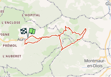
Trail Walking of 18.5 km to be discovered at Auvergne-Rhône-Alpes, Drôme, Aurel. This trail is proposed by ajd26.
Description
depuis le camping d'Aurel, on accède aux crêtes par le col du Royet avec des vues superbes jusqu'au Pas d'Aix
Photos


Positioning
Country:
France
Region :
Auvergne-Rhône-Alpes
Department/Province :
Drôme
Municipality :
Aurel
Location:
Unknown
Start:(Dec)
Start:(UTM)
682642 ; 4951762 (31T) N.
Comments