


1610Voisins

maxEA65
User
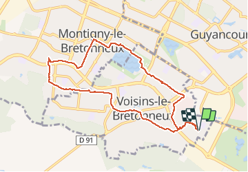

Length
8.9 km

Max alt
167 m

Uphill gradient
40 m
Km-Effort
9.5 km

Min alt
154 m

Downhill gradient
41 m
Boucle
Yes
Creation date :
2020-10-16 06:51:22.638
Updated on :
2020-10-16 09:31:15.332
2h39
Difficulty : Very easy

FREE GPS app for hiking
 SityTrail
IGN / Geographical institutes
SityTrail Plus
The world is yours!
About
Trail Walking of 8.9 km to be discovered at Ile-de-France, Yvelines, Voisins-le-Bretonneux. This trail is proposed by maxEA65.
Positioning
Country:
France
Region :
Ile-de-France
Department/Province :
Yvelines
Municipality :
Voisins-le-Bretonneux
Location:
Unknown
Start:(Dec)
Start:(UTM)
431274 ; 5400649 (31U) N.
Comments