


Larche à

MathieuBourgois
User
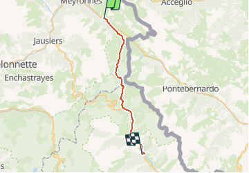

Length
29 km

Max alt
2670 m

Uphill gradient
1088 m
Km-Effort
45 km

Min alt
1143 m

Downhill gradient
1615 m
Boucle
No
Creation date :
2020-10-16 12:49:06.001
Updated on :
2020-10-16 12:51:27.359
--
Difficulty : Difficult

FREE GPS app for hiking
 SityTrail
IGN / Geographical institutes
SityTrail Plus
The world is yours!
About
Trail On foot of 29 km to be discovered at Provence-Alpes-Côte d'Azur, Alpes-de-Haute-Provence, Val-d'Oronaye. This trail is proposed by MathieuBourgois.
Description
Jonction avec le Tour du Mercantour
Le Pra 19km et 1000D
Positioning
Country:
France
Region :
Provence-Alpes-Côte d'Azur
Department/Province :
Alpes-de-Haute-Provence
Municipality :
Val-d'Oronaye
Location:
Larche
Start:(Dec)
Start:(UTM)
328640 ; 4924222 (32T) N.
Comments