


LA mussipontaine 35km

nouga
User
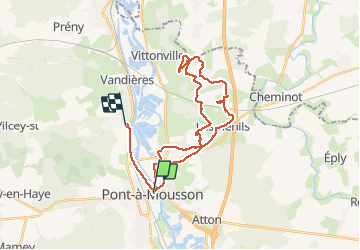

Length
32 km

Max alt
396 m

Uphill gradient
634 m
Km-Effort
40 km

Min alt
175 m

Downhill gradient
620 m
Boucle
No
Creation date :
2020-10-18 06:37:10.599
Updated on :
2020-10-18 11:00:05.461
4h20
Difficulty : Very easy

FREE GPS app for hiking
 SityTrail
IGN / Geographical institutes
SityTrail Plus
The world is yours!
About
Trail Mountain bike of 32 km to be discovered at Grand Est, Meurthe-et-Moselle, Pont-à-Mousson. This trail is proposed by nouga.
Description
Reconnaissance parcours de 35 km mussipontaine
Positioning
Country:
France
Region :
Grand Est
Department/Province :
Meurthe-et-Moselle
Municipality :
Pont-à-Mousson
Location:
Unknown
Start:(Dec)
Start:(UTM)
284249 ; 5420947 (32U) N.
Comments