


Vezenobres 2

boudpn
User
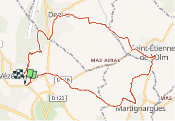

Length
14.6 km

Max alt
207 m

Uphill gradient
270 m
Km-Effort
18.2 km

Min alt
100 m

Downhill gradient
270 m
Boucle
Yes
Creation date :
2020-10-18 07:21:36.0
Updated on :
2020-10-18 13:26:23.376
6h04
Difficulty : Unknown

FREE GPS app for hiking
 SityTrail
IGN / Geographical institutes
SityTrail Plus
The world is yours!
About
Trail Walking of 14.6 km to be discovered at Occitania, Gard, Vézénobres. This trail is proposed by boudpn.
Description
Facile
Photos


Positioning
Country:
France
Region :
Occitania
Department/Province :
Gard
Municipality :
Vézénobres
Location:
Unknown
Start:(Dec)
Start:(UTM)
591224 ; 4878117 (31T) N.
Comments