


Anse Bertrand

sameja
User
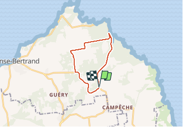

Length
12.7 km

Max alt
72 m

Uphill gradient
137 m
Km-Effort
14.5 km

Min alt
8 m

Downhill gradient
139 m
Boucle
Yes
Creation date :
2020-10-18 12:28:48.0
Updated on :
2020-10-18 14:15:35.09
1h37
Difficulty : Difficult

FREE GPS app for hiking
 SityTrail
IGN / Geographical institutes
SityTrail Plus
The world is yours!
About
Trail Trail of 12.7 km to be discovered at Guadeloupe, Unknown, Anse-Bertrand. This trail is proposed by sameja.
Description
Porte d’enfer la boucle
Positioning
Country:
France
Region :
Guadeloupe
Department/Province :
Unknown
Municipality :
Anse-Bertrand
Location:
Unknown
Start:(Dec)
Start:(UTM)
665445 ; 1820077 (20Q) N.
Comments