


2020-10-18 Drachenbronn

Bernardb44
User
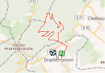

Length
9.2 km

Max alt
501 m

Uphill gradient
321 m
Km-Effort
13.4 km

Min alt
218 m

Downhill gradient
322 m
Boucle
Yes
Creation date :
2020-10-18 12:27:48.493
Updated on :
2020-10-18 15:41:45.451
3h13
Difficulty : Medium

FREE GPS app for hiking
 SityTrail
IGN / Geographical institutes
SityTrail Plus
The world is yours!
About
Trail Walking of 9.2 km to be discovered at Grand Est, Bas-Rhin, Drachenbronn-Birlenbach. This trail is proposed by Bernardb44.
Positioning
Country:
France
Region :
Grand Est
Department/Province :
Bas-Rhin
Municipality :
Drachenbronn-Birlenbach
Location:
Unknown
Start:(Dec)
Start:(UTM)
417171 ; 5426641 (32U) N.
Comments