


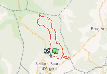
SEILLONS SUR ARGENS - SOURCE DE L'ARGENS

jean-marie.parachini
User

Length
15 km

Max alt
520 m

Uphill gradient
381 m
Km-Effort
20 km

Min alt
271 m

Downhill gradient
378 m
Boucle
Yes
Creation date :
2020-10-18 07:31:17.884
Updated on :
2020-10-18 16:52:21.08
5h33
Difficulty : Medium

FREE GPS app for hiking
 SityTrail
IGN / Geographical institutes
SityTrail Plus
The world is yours!
About
Trail Walking of 15 km to be discovered at Provence-Alpes-Côte d'Azur, Var, Seillons-Source-d'Argens. This trail is proposed by jean-marie.parachini.
Description
randonnée en forêt vers la source de l'Argens par des sentiers en pente douce mais rocailleux et à travers la garrigue.
Photos


Positioning
Country:
France
Region :
Provence-Alpes-Côte d'Azur
Department/Province :
Var
Municipality :
Seillons-Source-d'Argens
Location:
Unknown
Start:(Dec)
Start:(UTM)
733401 ; 4820796 (31T) N.
Comments