


Contour du lotissement Mt des Oiseaux

jmheydorff
User
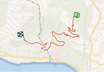

Length
4.3 km

Max alt
181 m

Uphill gradient
86 m
Km-Effort
5.6 km

Min alt
82 m

Downhill gradient
137 m
Boucle
No
Creation date :
2020-10-19 09:04:00.0
Updated on :
2020-10-19 10:23:06.587
1h18
Difficulty : Very easy

FREE GPS app for hiking
 SityTrail
IGN / Geographical institutes
SityTrail Plus
The world is yours!
About
Trail Walking of 4.3 km to be discovered at Provence-Alpes-Côte d'Azur, Var, Hyères. This trail is proposed by jmheydorff.
Positioning
Country:
France
Region :
Provence-Alpes-Côte d'Azur
Department/Province :
Var
Municipality :
Hyères
Location:
Unknown
Start:(Dec)
Start:(UTM)
265320 ; 4775178 (32T) N.
Comments