


Lambesc - la Bastide Blanche

mhetpierre
User
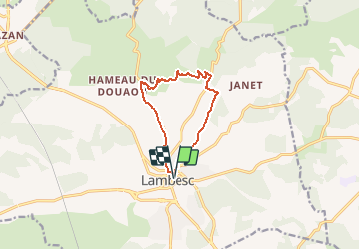

Length
10.1 km

Max alt
368 m

Uphill gradient
183 m
Km-Effort
12.5 km

Min alt
203 m

Downhill gradient
183 m
Boucle
Yes
Creation date :
2020-10-19 10:27:17.617
Updated on :
2021-03-05 16:03:50.942
--
Difficulty : Very easy

FREE GPS app for hiking
 SityTrail
IGN / Geographical institutes
SityTrail Plus
The world is yours!
About
Trail On foot of 10.1 km to be discovered at Provence-Alpes-Côte d'Azur, Bouches-du-Rhône, Lambesc. This trail is proposed by mhetpierre.
Positioning
Country:
France
Region :
Provence-Alpes-Côte d'Azur
Department/Province :
Bouches-du-Rhône
Municipality :
Lambesc
Location:
Unknown
Start:(Dec)
Start:(UTM)
682608 ; 4836025 (31T) N.
Comments