Alpes jour 14 : Larche à Bousiéyas
MathieuBourgois
User
Length
22 km
Max alt
2670 m
Uphill gradient
1356 m
Km-Effort
39 km
Min alt
1675 m
Downhill gradient
1032 m
Boucle
No
Creation date :
2020-10-19 11:47:09.195
Updated on :
2020-10-19 11:53:57.329
--
Difficulty : Difficult
FREE GPS app for hiking
About
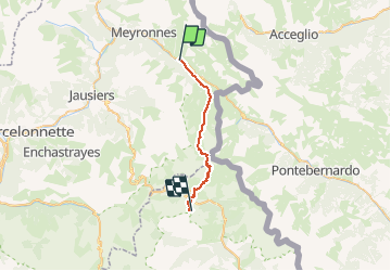
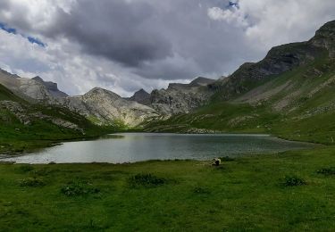
Trail On foot of 22 km to be discovered at Provence-Alpes-Côte d'Azur, Alpes-de-Haute-Provence, Val-d'Oronaye. This trail is proposed by MathieuBourgois.
Description
Pont Rouge 5.2km et 240D
Cabane Donnadieu 9km et 480D
Pas de Cavale 13km et 1000D
Col des Fourches 17km et 1200D
Bousiéyas 20km et 1200D
Bivouac 22km et 1350D
Positioning
Country:
France
Region :
Provence-Alpes-Côte d'Azur
Department/Province :
Alpes-de-Haute-Provence
Municipality :
Val-d'Oronaye
Location:
Larche
Start:(Dec)
Start:(UTM)
328620 ; 4924236 (32T) N.
Comments
Trails nearby
Saint Ours - Plateau de Mallemort
Walking
Very easy
(2)
Val-d'Oronaye,
Provence-Alpes-Côte d'Azur,
Alpes-de-Haute-Provence,
France
10.4 km | 15.4 km-effort
1h 49min
Yes
Fort de Rochecroix PR43
Walking
Medium
(1)
Val-d'Oronaye,
Provence-Alpes-Côte d'Azur,
Alpes-de-Haute-Provence,
France
10.1 km | 18.2 km-effort
6h 13min
No
Rando Tête de SAUTRON-Tête de VIRAYSSE
Walking
Medium
(1)
Val-d'Oronaye,
Provence-Alpes-Côte d'Azur,
Alpes-de-Haute-Provence,
France
20 km | 45 km-effort
6h 0min
Yes
LARCHE lac de la Orenaille .Tour du lac de Roburent o
Walking
Difficult
(2)
Val-d'Oronaye,
Provence-Alpes-Côte d'Azur,
Alpes-de-Haute-Provence,
France
14.2 km | 24 km-effort
6h 47min
Yes
fort roche la croix
Walking
Easy
(1)
Val-d'Oronaye,
Provence-Alpes-Côte d'Azur,
Alpes-de-Haute-Provence,
France
13.6 km | 23 km-effort
7h 11min
Yes
Batterie de Viraysse
Walking
Difficult
(1)
Val-d'Oronaye,
Provence-Alpes-Côte d'Azur,
Alpes-de-Haute-Provence,
France
17.4 km | 36 km-effort
6h 0min
Yes
Mont Scaletta (col de Larche)
Walking
Very difficult
Val-d'Oronaye,
Provence-Alpes-Côte d'Azur,
Alpes-de-Haute-Provence,
France
19 km | 34 km-effort
7h 39min
Yes
Lac du Lauzanier
Walking
Difficult
Val-d'Oronaye,
Provence-Alpes-Côte d'Azur,
Alpes-de-Haute-Provence,
France
14 km | 21 km-effort
4h 53min
Yes
FORT DE ST-OURS HAUT
Walking
Easy
Val-d'Oronaye,
Provence-Alpes-Côte d'Azur,
Alpes-de-Haute-Provence,
France
3.7 km | 5.2 km-effort
3h 15min
Yes