


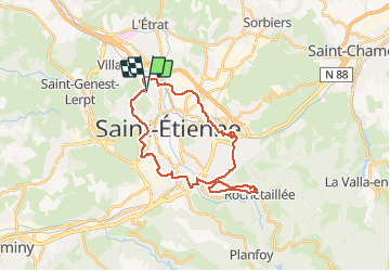
Voie verte Rochetaillée

psesjs
User

Length
29 km

Max alt
866 m

Uphill gradient
758 m
Km-Effort
39 km

Min alt
484 m

Downhill gradient
763 m
Boucle
Yes
Creation date :
2020-10-19 12:18:29.994
Updated on :
2020-10-19 14:33:50.981
2h11
Difficulty : Difficult
2h10
Difficulty : Difficult

FREE GPS app for hiking
 SityTrail
IGN / Geographical institutes
SityTrail Plus
The world is yours!
About
Trail Mountain bike of 29 km to be discovered at Auvergne-Rhône-Alpes, Loire, Saint-Étienne. This trail is proposed by psesjs.
Positioning
Country:
France
Region :
Auvergne-Rhône-Alpes
Department/Province :
Loire
Municipality :
Saint-Étienne
Location:
Unknown
Start:(Dec)
Start:(UTM)
607474 ; 5034565 (31T) N.
Comments