


St mandrier contournement

jmheydorff
User
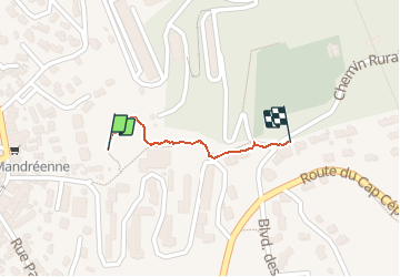

Length
440 m

Max alt
65 m

Uphill gradient
32 m
Km-Effort
760 m

Min alt
29 m

Downhill gradient
0 m
Boucle
No
Creation date :
2020-10-20 08:49:04.0
Updated on :
2020-10-20 09:00:47.882
12m
Difficulty : Easy

FREE GPS app for hiking
 SityTrail
IGN / Geographical institutes
SityTrail Plus
The world is yours!
About
Trail Walking of 440 m to be discovered at Provence-Alpes-Côte d'Azur, Var, Saint-Mandrier-sur-Mer. This trail is proposed by jmheydorff.
Positioning
Country:
France
Region :
Provence-Alpes-Côte d'Azur
Department/Province :
Var
Municipality :
Saint-Mandrier-sur-Mer
Location:
Unknown
Start:(Dec)
Start:(UTM)
738614 ; 4773560 (31T) N.
Comments