


Pla de Lalau-Refuge d'Esbints

ARVIEU
User
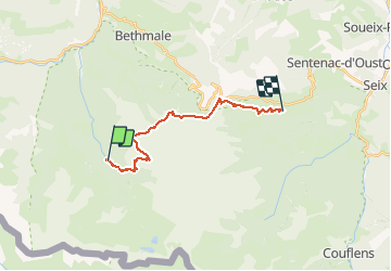

Length
19.3 km

Max alt
1926 m

Uphill gradient
1300 m
Km-Effort
37 km

Min alt
832 m

Downhill gradient
1416 m
Boucle
No
Creation date :
2020-10-21 12:49:42.195
Updated on :
2020-10-21 12:53:24.84
9h12
Difficulty : Very difficult

FREE GPS app for hiking
 SityTrail
IGN / Geographical institutes
SityTrail Plus
The world is yours!
About
Trail Walking of 19.3 km to be discovered at Occitania, Ariège, Bordes-Uchentein. This trail is proposed by ARVIEU.
Positioning
Country:
France
Region :
Occitania
Department/Province :
Ariège
Municipality :
Bordes-Uchentein
Location:
Les Bordes-sur-Lez
Start:(Dec)
Start:(UTM)
339319 ; 4743829 (31T) N.
Comments