


SityTrail - MAULEON- BAROUSSE La randonnee de Pey...

almitpau
User
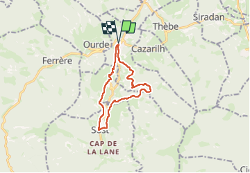

Length
11.5 km

Max alt
893 m

Uphill gradient
394 m
Km-Effort
16.8 km

Min alt
575 m

Downhill gradient
392 m
Boucle
Yes
Creation date :
2020-10-21 17:25:13.122
Updated on :
2024-06-21 17:08:29.762
3h48
Difficulty : Difficult

FREE GPS app for hiking
 SityTrail
IGN / Geographical institutes
SityTrail Plus
The world is yours!
About
Trail Walking of 11.5 km to be discovered at Occitania, Hautespyrenees, Mauléon-Barousse. This trail is proposed by almitpau.
Positioning
Country:
France
Region :
Occitania
Department/Province :
Hautespyrenees
Municipality :
Mauléon-Barousse
Location:
Unknown
Start:(Dec)
Start:(UTM)
301587 ; 4759195 (31T) N.
Comments