Trail Walking Tuchan - 20201022 Boucle -Tuchan-Padern-Tuchan - Photo

20201022 Boucle -Tuchan-Padern-Tuchan

 ThonyM
ThonyM

User

© OpenStreetMap contributors
Length
Length
19.9 km
Max alt
Max alt
677 m
Uphill gradient
Uphill gradient
642 m
Km-Effort
Km-Effort  
28 km
Min alt
Min alt
161 m
Downhill gradient
Downhill gradient
642 m
Boucle
Boucle
Yes
Creation date :
2020-10-22 06:47:28.0
Updated on :
2020-10-22 17:05:48.147

(0 Reviews)

Walking
Walking
4h41
Difficulty : Medium

Scan this QR Code to open this trail in the SityTrail application

FREE GPS app for hiking

Logo SityTrail SityTrail

IGN / Geographical institutes

Download SityTrail from the App Store Download SityTrail from Google Play

Logo SityTrail SityTrail World

The world is yours!

Download SityTrail from the App Store Download SityTrail from Google Play Download SityTrail on Huawei AppGallery

About

Trail Walking of 19.9 km to be discovered at Occitania, Aude, Tuchan. This trail is proposed by ThonyM.

Description

Un beau parcours un peu sportif avec de très belles vues

Elevation profile

Photos

Positioning

Country:
France
Region :
Occitania
Department/Province :
Aude
Municipality :
Tuchan
Location:
Unknown
Start:(UTM)
477117 ; 4748524 (31T) N.

Trails nearby

Trail Walking Vingrau - Chemin des Contrebandiers Vingrau variante - Photo
Walking
force

Walking

Medium
(2)
Vingrau, Occitania, Pyrénées-Orientales, France
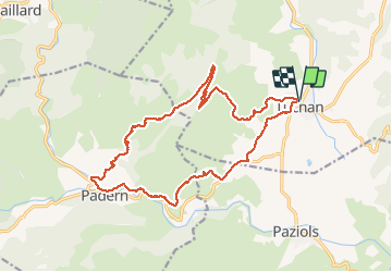
10.4 km | 16 km-effort
3h 30min
Yes
Trail Walking Vingrau - Vingrau - Photo
Walking
GUIDE
Ada11

Walking

Medium
Vingrau, Occitania, Pyrénées-Orientales, France
15.5 km | 22 km-effort
4h 20min
Yes
Trail Walking Paziols - paziols 19 kms - Photo
Walking
cappelle

Walking

Medium
Paziols, Occitania, Aude, France
18.6 km | 26 km-effort
6h 0min
Yes
Trail Walking Tuchan - 20220310 Tuchan-Padern - Photo
Walking
ThonyM

Walking

Medium
Tuchan, Occitania, Aude, France
23 km | 34 km-effort
5h 16min
Yes
Trail Walking Paziols - Paziols château d’aguilra - Photo
Walking
ombrabella

Walking

Very easy
Paziols, Occitania, Aude, France
15.1 km | 18.8 km-effort
4h 4min
Yes
Trail Walking Tuchan - 20211007 Tuchan-Padern-Queribus-Cucugnan - Photo
Walking
ThonyM

Walking

Medium
Tuchan, Occitania, Aude, France
25 km | 37 km-effort
5h 58min
No
Trail Walking Vingrau - 20201219 Vingrau - trauc del cavall - Photo
Walking
ThonyM

Walking

Difficult
Vingrau, Occitania, Pyrénées-Orientales, France
16.9 km | 24 km-effort
4h 49min
Yes
Trail Walking Vingrau - vingrau Chemin des contrebandiers_T - Photo
Walking
force

Walking

Medium
Vingrau, Occitania, Pyrénées-Orientales, France
15.3 km | 22 km-effort
4h 41min
Yes
Trail Mountain bike Tuchan - Tour des châteaux du Pays Cathare - Tuchan - Caudiès - Photo
Mountain bike
tracegps

Mountain bike

Very difficult
Tuchan, Occitania, Aude, France
60 km | 85 km-effort
4h 0min
No


Close
My subscriptions