


st Martin de Castillon Caseneuve

aupi
User
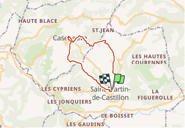

Length
11.5 km

Max alt
579 m

Uphill gradient
273 m
Km-Effort
15.1 km

Min alt
441 m

Downhill gradient
275 m
Boucle
Yes
Creation date :
2020-10-22 08:20:16.653
Updated on :
2020-10-22 15:52:15.739
4h45
Difficulty : Medium

FREE GPS app for hiking
 SityTrail
IGN / Geographical institutes
SityTrail Plus
The world is yours!
About
Trail Walking of 11.5 km to be discovered at Provence-Alpes-Côte d'Azur, Vaucluse, Saint-Martin-de-Castillon. This trail is proposed by aupi.
Positioning
Country:
France
Region :
Provence-Alpes-Côte d'Azur
Department/Province :
Vaucluse
Municipality :
Saint-Martin-de-Castillon
Location:
Unknown
Start:(Dec)
Start:(UTM)
701940 ; 4859540 (31T) N.
Comments