Trail Road bike Latronquière - Saint-Céré - Photo
© OpenStreetMap contributors
Length
Length
62 km
Max alt
Max alt
675 m
Uphill gradient
Uphill gradient
1053 m
Km-Effort
Km-Effort  
76 km
Min alt
Min alt
150 m
Downhill gradient
Downhill gradient
1053 m
Boucle
Boucle
Yes
Creation date :
2020-10-24 08:15:41.657
Updated on :
2020-10-24 15:46:01.346

(0 Reviews)

Road bike
Road bike
3h15
Difficulty : Medium

Scan this QR Code to open this trail in the SityTrail application

FREE GPS app for hiking

Logo SityTrail SityTrail

IGN / Geographical institutes

Download SityTrail from the App Store Download SityTrail from Google Play

Logo SityTrail SityTrail World

The world is yours!

Download SityTrail from the App Store Download SityTrail from Google Play Download SityTrail on Huawei AppGallery

About

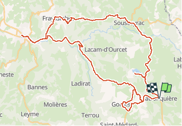
Trail Road bike of 62 km to be discovered at Occitania, Lot, Latronquière. This trail is proposed by Jean-Marie Bousquet.

Description

boucle au départ de Latronquiere avec passage au lac de Tolerme

Elevation profile

Positioning

Country:
France
Region :
Occitania
Department/Province :
Lot
Municipality :
Latronquière
Location:
Unknown
Start:(UTM)
426942 ; 4961081 (31T) N.

Trails nearby

Trail Walking Lauresses - Circuit des chemins creux et châtaigniers,-  Lauresses - Photo
Walking
tracegps

Walking

Easy
(2)
Lauresses, Occitania, Lot, France
7.8 km | 9.6 km-effort
2h 0min
Yes
Trail Walking Sénaillac-Latronquière - Lac du Tolerme  - Photo
Walking
Gegetop

Walking

Very easy
Sénaillac-Latronquière, Occitania, Lot, France
5.5 km | 6.5 km-effort
1h 46min
Yes
Trail Walking Sénaillac-Latronquière - Circuit du lac du Tolerme - Sénaillac-Latronquière - Photo
Walking
tracegps

Walking

Medium
(1)
Sénaillac-Latronquière, Occitania, Lot, France
8.9 km | 11.1 km-effort
2h 30min
Yes
Trail Equestrian Lauresses - Circuit des chemins creux et châtaigniers,-  Lauresses - Photo
Equestrian
tracegps

Equestrian

Easy
Lauresses, Occitania, Lot, France
7.8 km | 9.6 km-effort
1h 19min
Yes
Trail Mountain bike Lauresses - Circuit des chemins creux et châtaigniers,-  Lauresses - Photo
Mountain bike
tracegps

Mountain bike

Easy
Lauresses, Occitania, Lot, France
7.8 km | 9.6 km-effort
40min
Yes
Trail Walking Sénaillac-Latronquière - Tolerme Lac - Photo
Walking
gcournac

Walking

Easy
Sénaillac-Latronquière, Occitania, Lot, France
4.9 km | 5.6 km-effort
1h 31min
Yes
Trail Walking Latronquière - étang du roc - Photo
Walking
thomas.o.vert

Walking

Medium
Latronquière, Occitania, Lot, France
11.8 km | 14.9 km-effort
2h 46min
Yes
Trail Walking Lauresses - lauresses - Photo
Walking
VACHER31

Walking

Medium
Lauresses, Occitania, Lot, France
7.3 km | 9 km-effort
1h 48min
No
Trail Mountain bike Gorses - Entre le Lac de Tolerme et  Sousceyrac-en-Quercy - Photo
Mountain bike
sebcar

Mountain bike

Difficult
(1)
Gorses, Occitania, Lot, France
23 km | 30 km-effort
2h 30min
Yes


Close
My subscriptions