


26 combovin crest

randodyssée
User GUIDE
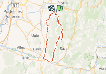

Length
55 km

Max alt
846 m

Uphill gradient
1108 m
Km-Effort
70 km

Min alt
186 m

Downhill gradient
1109 m
Boucle
Yes
Creation date :
2020-10-25 09:11:10.438
Updated on :
2020-10-25 13:45:41.539
3h37
Difficulty : Medium

FREE GPS app for hiking
 SityTrail
IGN / Geographical institutes
SityTrail Plus
The world is yours!
About
Trail Road bike of 55 km to be discovered at Auvergne-Rhône-Alpes, Drôme, Combovin. This trail is proposed by randodyssée.
Description
25 X 2020
Positioning
Country:
France
Region :
Auvergne-Rhône-Alpes
Department/Province :
Drôme
Municipality :
Combovin
Location:
Unknown
Start:(Dec)
Start:(UTM)
664088 ; 4970739 (31T) N.
Comments