


castanet

bouscaillou
User
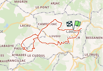

Length
21 km

Max alt
463 m

Uphill gradient
451 m
Km-Effort
27 km

Min alt
314 m

Downhill gradient
453 m
Boucle
Yes
Creation date :
2020-10-25 08:32:27.703
Updated on :
2020-10-25 15:30:25.705
6h54
Difficulty : Easy

FREE GPS app for hiking
 SityTrail
IGN / Geographical institutes
SityTrail Plus
The world is yours!
About
Trail Walking of 21 km to be discovered at Occitania, Tarn-et-Garonne, Castanet. This trail is proposed by bouscaillou.
Positioning
Country:
France
Region :
Occitania
Department/Province :
Tarn-et-Garonne
Municipality :
Castanet
Location:
Unknown
Start:(Dec)
Start:(UTM)
416203 ; 4902016 (31T) N.
Comments