


font jouable 2 baumes RoustanEymian

Nathy8913
User
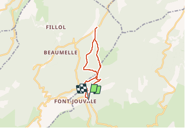

Length
11.8 km

Max alt
740 m

Uphill gradient
406 m
Km-Effort
17.1 km

Min alt
416 m

Downhill gradient
391 m
Boucle
Yes
Creation date :
2020-10-25 08:45:42.452
Updated on :
2020-10-25 16:57:25.786
5h15
Difficulty : Medium

FREE GPS app for hiking
 SityTrail
IGN / Geographical institutes
SityTrail Plus
The world is yours!
About
Trail Walking of 11.8 km to be discovered at Provence-Alpes-Côte d'Azur, Vaucluse, Saint-Saturnin-lès-Apt. This trail is proposed by Nathy8913.
Positioning
Country:
France
Region :
Provence-Alpes-Côte d'Azur
Department/Province :
Vaucluse
Municipality :
Saint-Saturnin-lès-Apt
Location:
Unknown
Start:(Dec)
Start:(UTM)
687437 ; 4870373 (31T) N.
Comments