


SityTrail - 11_Floure

dufland
User

Length
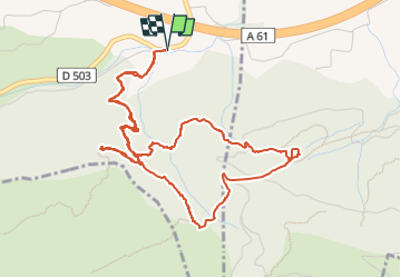
6.5 km

Max alt
361 m

Uphill gradient
315 m
Km-Effort
10.7 km

Min alt
93 m

Downhill gradient
315 m
Boucle
Yes
Creation date :
2020-10-26 12:49:08.947
Updated on :
2022-07-17 08:44:29.786
2h26
Difficulty : Medium

FREE GPS app for hiking
 SityTrail
IGN / Geographical institutes
SityTrail Plus
The world is yours!
About
Trail Walking of 6.5 km to be discovered at Occitania, Aude, Floure. This trail is proposed by dufland.
Description
Montagne d'Alaric; garrigue
Positioning
Country:
France
Region :
Occitania
Department/Province :
Aude
Municipality :
Floure
Location:
Unknown
Start:(Dec)
Start:(UTM)
458584 ; 4780542 (31T) N.
Comments