


ARS SUR FORMANS / Toussieux (16 km - D. 220 m)

Thomasdanielle
User
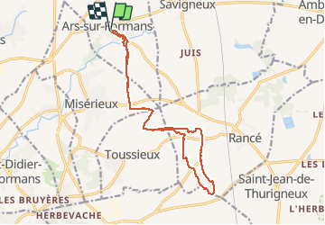

Length
16 km

Max alt
291 m

Uphill gradient
219 m
Km-Effort
18.9 km

Min alt
232 m

Downhill gradient
218 m
Boucle
Yes
Creation date :
2020-10-26 12:56:32.0
Updated on :
2020-10-30 10:34:45.314
3h49
Difficulty : Easy

FREE GPS app for hiking
 SityTrail
IGN / Geographical institutes
SityTrail Plus
The world is yours!
About
Trail Walking of 16 km to be discovered at Auvergne-Rhône-Alpes, Ain, Ars-sur-Formans. This trail is proposed by Thomasdanielle.
Description
D/A parking de centre d'Ars
Positioning
Country:
France
Region :
Auvergne-Rhône-Alpes
Department/Province :
Ain
Municipality :
Ars-sur-Formans
Location:
Unknown
Start:(Dec)
Start:(UTM)
640857 ; 5094945 (31T) N.
Comments