


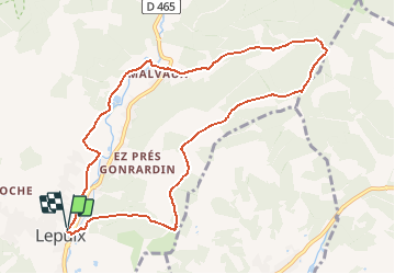
LEPUIX - Col du Chantoiseau - MALVAUX - LEPUIX

patrickbeyrath
User

Length
9.8 km

Max alt
967 m

Uphill gradient
480 m
Km-Effort
16.2 km

Min alt
500 m

Downhill gradient
479 m
Boucle
Yes
Creation date :
2018-10-13 05:53:09.913
Updated on :
2018-10-13 05:53:09.927
3h20
Difficulty : Medium

FREE GPS app for hiking
 SityTrail
IGN / Geographical institutes
SityTrail Plus
The world is yours!
About
Trail Walking of 9.8 km to be discovered at Bourgogne-Franche-Comté, Territoire-de-Belfort, Lepuix. This trail is proposed by patrickbeyrath.
Positioning
Country:
France
Region :
Bourgogne-Franche-Comté
Department/Province :
Territoire-de-Belfort
Municipality :
Lepuix
Location:
Unknown
Start:(Dec)
Start:(UTM)
336609 ; 5291952 (32T) N.
Comments