


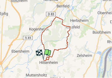
SityTrail - Boucle attelage Hilsenheim - Huttenheim

Tourisme Equestre Alsace
Promouvoir le Tourisme Equestre en Alsace GUIDE+


3h17
Difficulty : Medium
--
Difficulty : Easy

FREE GPS app for hiking
 SityTrail
IGN / Geographical institutes
SityTrail Plus
The world is yours!
About
Trail Horseback riding of 24 km to be discovered at Grand Est, Bas-Rhin, Hilsenheim. This trail is proposed by Tourisme Equestre Alsace.
Description
Balade pour attelages au départ du parking du terrain de foot de Hilsenheim. Halte équestre à Huttenheim.
Photos


Positioning
Comments