


Escalquens bas

Yannick.Boireau
User
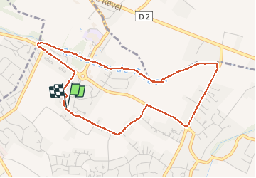

Length
5.1 km

Max alt
211 m

Uphill gradient
51 m
Km-Effort
5.8 km

Min alt
176 m

Downhill gradient
51 m
Boucle
Yes
Creation date :
2020-10-31 15:56:45.724
Updated on :
2020-10-31 17:18:04.194
1h20
Difficulty : Very easy

FREE GPS app for hiking
 SityTrail
IGN / Geographical institutes
SityTrail Plus
The world is yours!
About
Trail Walking of 5.1 km to be discovered at Occitania, Haute-Garonne, Escalquens. This trail is proposed by Yannick.Boireau.
Positioning
Country:
France
Region :
Occitania
Department/Province :
Haute-Garonne
Municipality :
Escalquens
Location:
Unknown
Start:(Dec)
Start:(UTM)
382833 ; 4820488 (31T) N.
Comments