


Calmont

richardsimopons
User
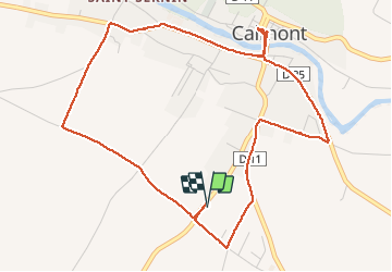

Length
6 km

Max alt
227 m

Uphill gradient
37 m
Km-Effort
6.4 km

Min alt
209 m

Downhill gradient
37 m
Boucle
Yes
Creation date :
2020-11-01 09:25:20.0
Updated on :
2020-11-01 11:20:19.648
1h36
Difficulty : Unknown

FREE GPS app for hiking
 SityTrail
IGN / Geographical institutes
SityTrail Plus
The world is yours!
About
Trail Walking of 6 km to be discovered at Occitania, Haute-Garonne, Calmont. This trail is proposed by richardsimopons.
Description
Boucle de confinement
Positioning
Country:
France
Region :
Occitania
Department/Province :
Haute-Garonne
Municipality :
Calmont
Location:
Unknown
Start:(Dec)
Start:(UTM)
388713 ; 4792490 (31T) N.
Comments