


24898

Doubotis
User ADMIN
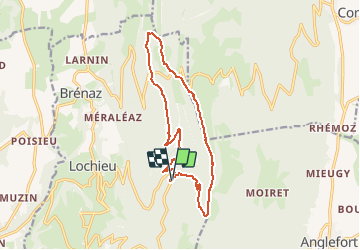

Length
14.6 km

Max alt
1417 m

Uphill gradient
677 m
Km-Effort
24 km

Min alt
981 m

Downhill gradient
686 m
Boucle
Yes
Creation date :
2020-11-03 11:33:20.0
Updated on :
2020-11-03 11:33:43.421

FREE GPS app for hiking
 SityTrail
IGN / Geographical institutes
SityTrail Plus
The world is yours!
About
Trail of 14.6 km to be discovered at Auvergne-Rhône-Alpes, Ain, Arvière-en-Valromey. This trail is proposed by Doubotis.
Positioning
Country:
France
Region :
Auvergne-Rhône-Alpes
Department/Province :
Ain
Municipality :
Arvière-en-Valromey
Location:
Unknown
Start:(Dec)
Start:(UTM)
713578 ; 5089568 (31T) N.
Comments