


CHATEAU NEUF VAL SAINT DONAT Jas de l ami , Jas de Calais , Chemin des Bouis des Bœufs n

RobinMicheline
User GUIDE
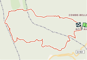

Length
14 km

Max alt
1237 m

Uphill gradient
618 m
Km-Effort
22 km

Min alt
709 m

Downhill gradient
618 m
Boucle
Yes
Creation date :
2020-11-03 06:24:10.633
Updated on :
2020-11-03 17:09:12.523
4h06
Difficulty : Medium

FREE GPS app for hiking
 SityTrail
IGN / Geographical institutes
SityTrail Plus
The world is yours!
About
Trail Walking of 14 km to be discovered at Provence-Alpes-Côte d'Azur, Alpes-de-Haute-Provence, Châteauneuf-Val-Saint-Donat. This trail is proposed by RobinMicheline.
Photos


Positioning
Country:
France
Region :
Provence-Alpes-Côte d'Azur
Department/Province :
Alpes-de-Haute-Provence
Municipality :
Châteauneuf-Val-Saint-Donat
Location:
Unknown
Start:(Dec)
Start:(UTM)
734225 ; 4885898 (31T) N.
Comments