


Le stand de tir

francisdean
User
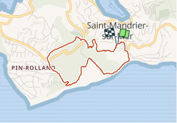

Length
4.1 km

Max alt
88 m

Uphill gradient
151 m
Km-Effort
6.2 km

Min alt
2 m

Downhill gradient
151 m
Boucle
Yes
Creation date :
2020-11-04 10:06:20.027
Updated on :
2020-11-04 11:32:31.753
1h03
Difficulty : Easy

FREE GPS app for hiking
 SityTrail
IGN / Geographical institutes
SityTrail Plus
The world is yours!
About
Trail Walking of 4.1 km to be discovered at Provence-Alpes-Côte d'Azur, Var, Saint-Mandrier-sur-Mer. This trail is proposed by francisdean.
Positioning
Country:
France
Region :
Provence-Alpes-Côte d'Azur
Department/Province :
Var
Municipality :
Saint-Mandrier-sur-Mer
Location:
Unknown
Start:(Dec)
Start:(UTM)
738265 ; 4773223 (31T) N.
Comments