


Alaric fount des mourel

elexine23
User
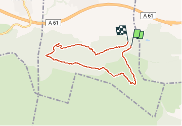

Length
7.7 km

Max alt
432 m

Uphill gradient
357 m
Km-Effort
12.5 km

Min alt
137 m

Downhill gradient
374 m
Boucle
Yes
Creation date :
2020-11-05 12:04:20.07
Updated on :
2020-11-05 16:11:18.674
2h59
Difficulty : Easy

FREE GPS app for hiking
 SityTrail
IGN / Geographical institutes
SityTrail Plus
The world is yours!
About
Trail Walking of 7.7 km to be discovered at Occitania, Aude, Barbaira. This trail is proposed by elexine23.
Positioning
Country:
France
Region :
Occitania
Department/Province :
Aude
Municipality :
Barbaira
Location:
Unknown
Start:(Dec)
Start:(UTM)
461513 ; 4780008 (31T) N.
Comments