


Calmont 2

richardsimopons
User
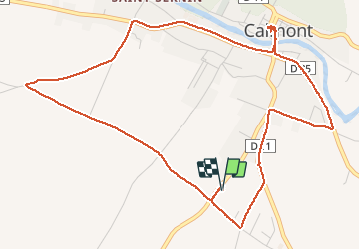

Length
6.8 km

Max alt
227 m

Uphill gradient
40 m
Km-Effort
7.4 km

Min alt
209 m

Downhill gradient
40 m
Boucle
Yes
Creation date :
2020-11-06 07:55:44.0
Updated on :
2020-11-06 09:41:11.665
1h33
Difficulty : Unknown

FREE GPS app for hiking
 SityTrail
IGN / Geographical institutes
SityTrail Plus
The world is yours!
About
Trail Walking of 6.8 km to be discovered at Occitania, Haute-Garonne, Calmont. This trail is proposed by richardsimopons.
Description
Boucle de confinement: the best.
Photos


Positioning
Country:
France
Region :
Occitania
Department/Province :
Haute-Garonne
Municipality :
Calmont
Location:
Unknown
Start:(Dec)
Start:(UTM)
388713 ; 4792484 (31T) N.
Comments