


BALADE INCERTAINE

surceneux
User
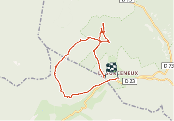

Length
8 km

Max alt
997 m

Uphill gradient
285 m
Km-Effort
11.9 km

Min alt
814 m

Downhill gradient
319 m
Boucle
No
Creation date :
2020-11-09 13:29:41.174
Updated on :
2020-11-09 15:52:42.032
2h08
Difficulty : Medium

FREE GPS app for hiking
 SityTrail
IGN / Geographical institutes
SityTrail Plus
The world is yours!
About
Trail Walking of 8 km to be discovered at Grand Est, Vosges, Ban-sur-Meurthe-Clefcy. This trail is proposed by surceneux.
Description
SURCENEUX LES BASSES DE L'EAU FONIE SURCENEUX
Positioning
Country:
France
Region :
Grand Est
Department/Province :
Vosges
Municipality :
Ban-sur-Meurthe-Clefcy
Location:
Unknown
Start:(Dec)
Start:(UTM)
347484 ; 5329032 (32U) N.
Comments