


oliveraie

Bwattier
User
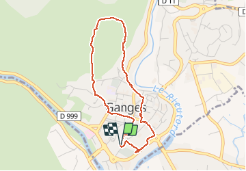

Length
3.9 km

Max alt
230 m

Uphill gradient
87 m
Km-Effort
5.1 km

Min alt
147 m

Downhill gradient
90 m
Boucle
Yes
Creation date :
2020-11-10 13:05:00.293
Updated on :
2020-11-10 14:22:11.739
1h16
Difficulty : Very easy

FREE GPS app for hiking
 SityTrail
IGN / Geographical institutes
SityTrail Plus
The world is yours!
About
Trail Walking of 3.9 km to be discovered at Occitania, Hérault, Ganges. This trail is proposed by Bwattier.
Positioning
Country:
France
Region :
Occitania
Department/Province :
Hérault
Municipality :
Ganges
Location:
Unknown
Start:(Dec)
Start:(UTM)
556704 ; 4864539 (31T) N.
Comments